
 Beautiful sceneries, beautiful wildlife
  Hundreds of holiday destinations and features to behold
  The roaring king of the jungle
  The phenomenal eighth wonder of the world - the wildebeest migration
  Rhinos, black and white, can be found in Kenya and Tanzania
  Dine with the giraffes at Giraffe Manor
  We have flying safaris to different destinations
  Variety of camping safaris to select from
  The camps are clean, with all necessary facilities
  0
0  1
1  2
2  3
3  4
4  5
5  6
6  7
7  8
8 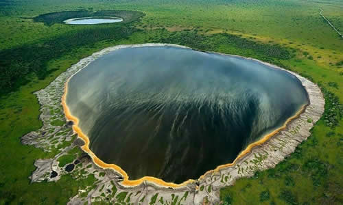 Ngorongoro Crater, a large volcanic caldera within the area. The conservation area is administered by the Ngorongoro Conservation Area Authority, an arm of the Tanzanian government, and its boundaries follow the boundary of the Ngorongoro Division of the Arusha Region. There are different tree species dotted with watering holes and shelters almost 30,000 animals in an area naturally enclosed by the walls of the volcano. Enjoy a game drive on the crater phone. This is only park where the black rhino could be spotted. There is a variety of grazing herbivores, as well as the predators that are attracted by this abundant supply of prey. Other animals that can be seen here are elephants, lion, leopard and hyena, herds of wildebeest, buffalo, zebra, serval cat, cheetah, jackal, Grant’s and Thompson’s gazelle, flamingo and bat-eared foxes, as well as approximately 400 species of birds.
The Pliocene Ngorongoro volcanic complex consists of eight extinct shield volcanoes within the Eyasi half-graben, the eastern boundary marked by the Gregory Rift Western Escarpment. The Lake Eyasi escarpment bounds the half-graben on the southwest. Within the complex, five volcanoes are dome-shaped cones, while three have calderas. Ngorongoro Volcano (2.5–1.9 Ma) is primarily basaltic trachyandesite. The caldera is fed by the Munge and Oljoro Nyuki Rivers, while the Ngoitokitok hot springs feed into the Goringop swamp. Lake Magadi is a shallow (1.7 m) alkaline lake. Other volcanoes within the complex include Olmoti (2.01–1.79 Ma), Empakaai, Loolmalasin, Sadiman (3.7 Ma), Lemagrut, and Oldeani. The northwest portion of the conservation area consists of the Serengeti Plains, the Salei Plains, the Oldupai Gorge, and the Gol Mountains inselbergs. These inselbergs are part of the Mozambique Belt quartzite and mica schist about (800–500 Ma) in age.


